








The Wildlife Corridors We Cannot See Are Becoming More Important Than Ever
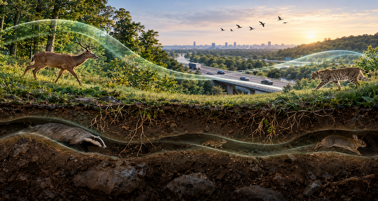
A wildlife corridor does not always look like a corridor. There may be no fence, road sign or clearly defined strip of protected land. In many cases, it is simply the route an animal repeatedly uses to move between feeding grounds, breeding areas, seasonal habitats or refuge.
Modern tracking technology is making these invisible pathways easier to see.
GPS collars, satellite tracking and movement models are revealing that wildlife depends on networks of connected places rather than isolated protected areas. A deer may cross several jurisdictions during a seasonal migration. A bird may depend on a chain of wetlands separated by hundreds or thousands of kilometers. Marine animals may travel through enormous areas of ocean that cannot be recognized as corridors from the surface.
That distinction is becoming increasingly important as roads, fences, development and changing climate conditions alter the landscapes through which animals move. Conservation is therefore shifting from protecting individual places to understanding the connections between them.
Key Takeaways
- Wildlife corridors are often functional pathways identified through animal movement rather than visible boundaries on the ground.
- GPS and satellite tracking are revealing migration routes, stopovers and bottlenecks that conventional maps can miss.
- Climate change can make connectivity more important as species adjust their ranges and seasonal movements.
- A small interruption at a migration bottleneck can have consequences far beyond the size of the affected area.
- Marine animals also depend on interconnected migratory networks spanning large portions of the global ocean.
- Effective corridor conservation increasingly requires cooperation across landowners, agencies, borders and jurisdictions.
The Corridor May Exist Only When an Animal Uses It
The word “corridor” can create the impression of a narrow strip of habitat, similar to a road connecting two destinations. Ecological connectivity is more complicated.
Some corridors are relatively obvious. A forested passage between two habitat blocks may allow animals to move safely. A wildlife overpass can physically reconnect habitats separated by a highway.
But other corridors are defined by animal behavior.
USGS research on migratory wildlife describes routes that animals use to move between seasonal habitats, including pathways used by big-game species, birds, bats, amphibians, reptiles and fish. These routes can cross landscapes with different ownership, land uses and levels of protection.
That means a place can be ecologically important even if it does not look particularly special to a person standing there.
A stretch of grassland, a riverbank, a mountain pass or a relatively narrow strip of undeveloped land may become critical when it represents one of the few practical routes connecting two seasonal habitats.
The importance can be especially difficult to see when the animals themselves are rarely observed.
Technology Is Turning Movement Into Maps
One of the biggest changes in wildlife conservation has been the ability to track individual animals over long periods.
GPS collars and other tracking technologies allow researchers to collect repeated locations from animals as they move through landscapes. Those observations can then be analyzed to identify frequently used routes, seasonal ranges and areas where movement becomes concentrated.
USGS’s Migration Mapper, for example, was developed to help researchers analyze GPS collar data and identify population-level movement corridors and seasonal ranges.
The resulting maps can change how conservationists understand a landscape.
Instead of asking only, “Where does wildlife live?” researchers can ask:
- Where does it move?
- When does it move?
- Which places does it repeatedly use?
- Where does movement narrow?
- Which roads, fences or developments interfere with movement?
- Which areas connect otherwise separated habitats?
That additional information matters because protecting a destination does not necessarily protect the journey required to reach it.
The Most Important Places May Be the Narrowest
One of the most revealing features of wildlife connectivity is the migration bottleneck.
A bottleneck is a relatively narrow part of a broader movement route where geography, vegetation or human development constrains animal movement. Because the available space is already limited, relatively small changes can have disproportionately large consequences.
USGS research gives the example of Trapper’s Point in Wyoming, a well-known mule deer and pronghorn migration bottleneck. Historical development and transportation infrastructure narrowed the available route substantially, making the remaining connection particularly important.
This illustrates why the size of a conservation area alone can be misleading.
A large protected landscape may have limited value for connectivity if an essential passage between two habitats is blocked. Conversely, a comparatively small piece of land can have considerable ecological importance if it keeps a larger network connected.
The invisible corridor therefore has a physical vulnerability: it may depend on a surprisingly small number of usable connections.
Roads and Fences Can Change the Map Without Changing the Habitat
A landscape does not have to be completely destroyed to become less useful to wildlife.
A road can divide habitat. A fence can restrict movement. Housing can narrow a passage. Energy infrastructure can alter how animals use an area. A border barrier can interrupt movement across an otherwise continuous ecosystem.
A 2025 review in Biological Conservation examined research on international border fences and walls and found documented concerns involving habitat fragmentation, gene flow, access to water and climate-related impacts. The authors also identified cooperation and technologies as potential parts of the response.
The important point is that connectivity is about permeability, not simply whether vegetation remains on a map.
An area may still appear green from above while becoming increasingly difficult for wildlife to cross.
Climate Change Makes Connectivity More Dynamic
Wildlife corridors were already important before climate change became a central conservation challenge. A changing climate adds another layer of complexity.
As temperature, precipitation, snow conditions and vegetation patterns change, some species may alter the timing, location or route of their movements.
USGS research on elk, mule deer and pronghorn identifies several possible pathways through which climate change could influence migration. Animals may change migration timing, alter routes or distances, or show greater variation in whether they migrate from year to year.
This means a corridor should not always be understood as a permanent line on a map.
The route that works under one set of environmental conditions may become less suitable under another.
Connected landscapes give animals more opportunities to respond to those changes. Fragmented landscapes can reduce those options.
This is one reason the IUCN describes ecological connectivity as important for climate adaptation as well as biodiversity conservation. Its global guidelines emphasize connections among protected areas, conserved areas and other intact ecosystems.
The Invisible Network Extends Into the Ocean
The concept becomes even more striking in marine ecosystems.
There are no visible highways across the open ocean, yet marine animals can follow recurring movement patterns between feeding, breeding and other important areas.
A 2025 Nature Communications study synthesized more than 1,300 references to identify 1,787 sites and model migratory networks for 109 marine species. The research illustrates the scale at which marine connectivity must be considered: protecting individual sites may not be sufficient when animals depend on networks linking multiple locations.
Another 2025 study published in Science analyzed 11 million geographic positions from 15,845 tracked marine animals across 121 species. It found that large areas used by marine megafauna function as important migratory corridors or residence areas, highlighting potential gaps between where conservation protection exists and where highly mobile animals actually spend time.
The ocean therefore provides perhaps the clearest example of why “corridor” should not be interpreted as a visible physical structure.
The corridor can be a pattern of movement across a vast environment.
Conservation Is Becoming More About Connections
The growing ability to map animal movement is changing conservation planning.
In the western United States, USGS and partner agencies have been systematically mapping ungulate migrations. The fifth volume of the Ungulate Migrations of the Western United States series, published in 2025, added migration information for 36 additional herds and updates for two previously documented herds.
These maps are not simply scientific illustrations. They can help transportation agencies, land managers and conservation organizations identify where infrastructure or land-use decisions intersect with animal movement.
There is a practical example in Nevada and neighboring western states. USGS documentation describes how GPS collar data, wildlife-vehicle collision records and other evidence have been used to identify migration corridors and inform wildlife-crossing projects.
This represents a broader change in conservation thinking.
Instead of treating wildlife protection as a collection of isolated protected areas, planners can increasingly think in terms of networks:
habitat → movement route → bottleneck → seasonal habitat → movement route → refuge
If one important link disappears, the consequences may extend through the network.
Why “Invisible” Does Not Mean Unimportant
There is a useful lesson in the way these corridors are being discovered.
Human landscapes are usually organized around visible infrastructure: roads, property boundaries, buildings, power lines and political borders. Wildlife does not necessarily recognize those boundaries.
An animal’s map is built around food, water, shelter, reproduction, temperature, terrain and risk.
That creates a fundamental mismatch.
A development decision can appear small when viewed from a property map but become significant when viewed from the movement map of an animal population.
The same principle applies across borders. A migration route does not stop because an administrative boundary appears on a human map.
IUCN’s connectivity guidance therefore treats ecological corridors as part of larger ecological networks rather than isolated conservation features.
The Next Challenge Is Keeping the Network Functional
Finding a corridor is only the first step.
Researchers still have to determine how consistently animals use it, whether the route changes over time, which threats matter most, and what intervention would actually improve connectivity.
Even corridor mapping has technical limitations. USGS researchers have noted that different analytical methods can produce substantially different corridor widths and sometimes fragmented-looking routes, complicating decisions about how much land needs protection.
That uncertainty is important.
A map should not automatically be treated as a perfect boundary. It is an evidence-based representation of animal movement, produced using particular data and analytical assumptions.
The most effective conservation planning therefore requires continued monitoring rather than treating a corridor map as permanent.
As environmental conditions change, the map may need to change with them.
Conclusion
The most important wildlife habitat may not always be the place that looks most valuable on a conventional map.
Sometimes its importance lies in what happens there between two other places.
Modern tracking technology is making those connections increasingly visible. GPS collars, satellite tracking, movement models and large-scale ecological datasets are revealing routes that animals have depended on for generations, including terrestrial migration corridors, narrow bottlenecks and vast marine networks.
The broader implication is straightforward: conservation cannot be measured only by how much land or ocean is protected. It also has to consider whether wildlife can still move through the spaces between protected places.
A corridor does not need to have a fence around it to be real.
Sometimes, the strongest evidence that a pathway matters is simply that wildlife keeps using it.
This content is published for informational or entertainment purposes. Facts, opinions, or references may evolve over time, and readers are encouraged to verify details from reliable sources.