










The Ancient Roads Still Shaping the Cities We Live In
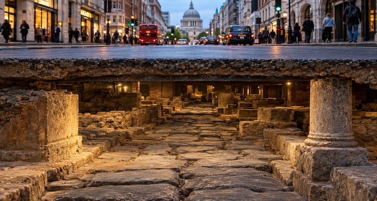
A modern city can look entirely new on the surface while carrying an unexpectedly old map underneath. Beneath roads, buildings and pavements, archaeologists can find earlier streets, roadbeds, drainage systems and settlement boundaries sometimes following routes that modern traffic still uses.
This is not simply a story about buried stones. Roads are unusually persistent pieces of infrastructure because they connect places that remain useful to connect: river crossings, ports, hills, settlements, markets and administrative centers. Once a route becomes established, later communities often have good reasons to repair it, widen it, divert it slightly or build directly over it rather than abandon it.
Evidence from Britain, Greece and other parts of the ancient world shows that this process can continue for centuries. In London, sections of Roman roads survive beneath or alongside modern development. In Greece, parts of the ancient Via Egnatia have influenced later transportation routes. At Herculaneum, entire areas of the ancient city remain beneath the modern town.
The result is an urban landscape that behaves less like a clean replacement of one city by another and more like a layered manuscript: old routes remain legible even when the original city has disappeared.
Key Takeaways
- Ancient roads often survived because later communities inherited useful routes rather than designing cities from scratch.
- Modern streets can preserve ancient alignments even when the original road surface has disappeared.
- London provides clear evidence of Roman roads and other archaeological remains surviving beneath modern development.
- Ancient road networks reveal more than transportation: they can expose patterns of trade, settlement, administration and urban growth.
- Ground-penetrating radar, magnetometry, LiDAR and GIS now help archaeologists investigate buried landscapes without extensive excavation.
- The deepest lesson is that modern cities are often historical layers built around decisions made centuries or millennia earlier.
A Road Does Not Have to Survive to Shape a City
When people imagine an ancient road surviving beneath a modern city, it is tempting to picture a perfectly preserved stone highway directly underneath today’s asphalt.
Reality is usually more complicated.
A road may survive as an archaeological layer, while the modern street above follows only part of its original alignment. In other places, the ancient route may have disappeared physically but left a recognizable line in property boundaries, lanes, streets or later roads.
Historic England notes that many Roman roads in Britain continued in use after Roman rule ended and became sealed beneath modern roads. Others influenced later land boundaries or modern route patterns.
That distinction matters. The “afterlife” of an ancient road is not necessarily the survival of its original paving stones. It can be the survival of its function and geometry.
A route established because it crosses a river at a practical point may remain useful. A road climbing a particular slope may continue to be preferable to a completely new alignment. A street connecting two historically important districts can retain its purpose even after every building around it has changed.
The physical road may die. The route can remain.
London Shows How Ancient Routes Become Part of the Modern City
London offers an unusually clear example because the Roman city of Londinium lies beneath one of the world’s continuously inhabited major urban areas.
Historic England records Roman road remains at places including Tower Hill, where a section of Roman road survives alongside settlement remains and a medieval bastion. The agency also notes that some Roman routes continued into later periods and were eventually covered by modern roads.
The relationship becomes particularly interesting around the former Roman road connecting London and Colchester.
Historic England’s archaeological assessment for Newham identifies a projected Roman route through the area and notes that parts of modern Romford Road, Leytonstone High Street and Leytonstone Road are thought to have evolved from Roman or later versions of the route. Archaeological excavations have also uncovered sections of the Roman road.
That does not mean every metre of today’s street is a Roman road. Archaeological route reconstruction often involves different degrees of certainty. Some sections are excavated, some inferred from alignments, and others remain uncertain.
That uncertainty is itself important.
Ancient cities cannot always be reconstructed from a single piece of evidence. Archaeologists combine excavated remains with historical documents, topography, aerial imagery, geophysical surveys and patterns visible in later landscapes.
The Ancient Road Beneath the Modern Road Is Often a Stack of Roads
One of the most revealing features of urban archaeology is that a road can have multiple lives.
An ancient road might be repaired repeatedly. A later population might place a new surface over it. Drainage could be modified. The road might become narrower or wider. Buildings could encroach on its edges. Eventually another street could occupy roughly the same corridor.
Archaeologists therefore sometimes encounter stratigraphy rather than a single road: successive surfaces and modifications representing different periods of urban life.
A Historic England record at Bainesse near Catterick illustrates the principle. Excavations identified an earlier surface of the Roman Dere Street about 1.3 metres below the modern ground surface, while surviving Roman remains are expected beneath modern roads and buildings.
The buried layers are valuable precisely because they preserve change.
A single road surface tells archaeologists about construction. Several successive surfaces can reveal maintenance, abandonment, reuse and changing patterns of movement.
Roads Reveal the Logic of Ancient Cities
A road network is also a map of priorities.
Where people repeatedly chose to move can indicate where they needed to go. Roads connecting ports and settlements can illuminate trade. Routes crossing strategic terrain can reveal military considerations. Roads entering cities can point toward administrative or commercial centers.
The Roman road system in Britain demonstrates this broader function. Historic England describes Roman roads as infrastructure supporting administration and communication, while also noting their importance to commerce, settlement and industry.
The ancient Via Egnatia provides an even larger example.
The Greek Ministry of Culture describes the Via Egnatia as a major Roman military and commercial route linking the Adriatic with the Hellespont. It passed through regions that are now part of several modern countries and remained an important corridor across successive historical periods.
The significance is bigger than the surviving paving.
For more than two millennia, the corridor helped move people, goods and ideas across the Balkans. The modern road system does not perfectly reproduce the ancient route, but the relationship demonstrates how geography and established connections can exert long-term influence over transportation.
Sometimes the Old Route Is More Important Than the Old Pavement
The ancient Via Egnatia demonstrates why historians should be careful when talking about “roads surviving.”
At some locations, ancient sections remain visible. At others, later roads have damaged or obscured them. In the Evros region of Greece, for example, parts of the ancient route survive near modern highways, while some modern forest roads have followed the ancient alignment closely enough to destroy portions of the archaeological roadbed.
This creates a fascinating reversal.
Modern infrastructure can simultaneously preserve an ancient route by keeping it in use and destroy archaeological evidence by building over it.
That tension is central to urban archaeology. A city that continues to grow does not simply protect its past; its development can both conceal and threaten it.
Herculaneum Shows What Happens When the City Above Keeps Growing
Sometimes the ancient landscape is not merely beneath a modern road. It is beneath an entire modern settlement.
UNESCO notes that substantial portions of ancient Herculaneum remain underneath the modern town of Ercolano. Some areas have been explored through historic tunnels, but large sections of the ancient city remain beneath the modern urban landscape.
This illustrates a fundamental problem with archaeological preservation in living cities.
Excavating everything is impossible.
Modern residents need homes, roads, utilities, transportation and businesses. Archaeologists therefore have to determine what can be investigated, what should remain undisturbed and what information can be recovered without destroying the archaeological context.
The result is that much of an ancient city may remain unknown not because researchers have forgotten about it, but because preserving the archaeological layer in place can be more responsible than exposing it.
Technology Is Changing How Archaeologists Find Buried Roads
The investigation of ancient roads increasingly begins without a shovel.
Modern archaeological surveys can combine geophysical techniques, aerial imagery, LiDAR, photogrammetry and geographic information systems to identify traces of buried landscapes.
Ground-penetrating radar, for example, can send electromagnetic pulses into the ground and record reflections from buried features. Historic England notes that GPR can work through surfaces such as tarmac and concrete and can produce detailed subsurface information at different depths.
Magnetometry can identify subtle differences in the magnetic properties of soils and buried materials. Other techniques measure electrical resistance or use remote sensing to identify landscape patterns. No single method works everywhere; geology, burial depth, surface conditions and the type of archaeological remains all affect what can be detected.
LiDAR adds another perspective.
By producing detailed measurements of the landscape surface, laser-based remote sensing can help researchers recognize subtle remains that are difficult to see at ground level. Researchers are also combining LiDAR with computational analysis to reconstruct ancient road networks and movement patterns. A 2022 study of Angamuco in Mexico used LiDAR and network analysis to identify more than 3,000 ancient roads and pathways, demonstrating how transportation networks can be studied as evidence of urban organization.
The technology does not make archaeology automatic. Interpretation remains essential. But it allows researchers to ask questions across much larger areas than conventional excavation alone could cover.
The City Beneath the City Is Not Always Where We Expect It
Ancient road archaeology also teaches an important lesson about certainty.
An apparent straight line on a map does not prove that an ancient road followed it.
Historic England’s research into a Roman road between Chichester and Arundel, for example, combined earthworks, cropmarks and high-resolution LiDAR to identify traces across portions of the landscape. Some areas remain masked by modern development, requiring researchers to distinguish documented remains from inferred routes.
Similarly, the London-to-Colchester Roman road has sections where its precise route remains uncertain because later development may have removed evidence or because alternative alignments remain possible.
That is why responsible archaeological writing should distinguish between excavated, identified, inferred and projected routes.
The map of an ancient city is often a probability map, not a perfect blueprint.
What Ancient Roads Tell Us About Modern Urban Design
The deeper significance of buried roads is not archaeological nostalgia. It is that cities have unusually long memories.
Modern urban planners may work with traffic counts, zoning, public transport and economic development. Ancient builders worked with different technologies and priorities. Yet both confront many of the same physical constraints: rivers, slopes, coastlines, access points and the need to connect concentrations of people.
This helps explain why urban form can be remarkably persistent.
A road corridor that made sense hundreds or thousands of years ago may continue to make sense even after the political system, language, buildings and technology surrounding it have changed.
In that sense, ancient roads are examples of infrastructure path dependence: earlier decisions can constrain or influence later ones because replacing an established route is costly, disruptive or simply unnecessary.
The modern city therefore inherits more than archaeological objects. It inherits choices.
Ancient Streets Are Historical Data, Not Just Ruins
An old road can reveal where people travelled. Its width can provide clues about its intended use. Wheel ruts can preserve evidence of carts. Drainage structures can indicate engineering responses to water. Adjacent buildings and cemeteries can reveal how movement interacted with settlement.
At Philippi, for instance, surviving portions of the Via Egnatia preserve paving and wheel ruts, while cemeteries and monuments developed alongside the route.
That combination turns a road into a record of social behavior.
The road tells us not simply that people moved from one location to another, but that movement organized other activities around it.
Markets, workshops, inns, administrative facilities and burial areas could all develop in relation to transportation corridors.
The road was infrastructure but it was also an organizing principle for urban life.
The Strange Afterlife of a Road
Perhaps the most interesting feature of ancient roads is that their survival rarely follows a simple pattern.
Some are preserved as archaeological monuments.
Some lie beneath modern streets.
Some survive as field boundaries.
Some have been partially destroyed but can still be reconstructed through remote sensing.
Some disappeared entirely, leaving only historical references and fragments of evidence.
And some continue to perform essentially the same geographical function after thousands of years.
Athens offers another example of this layered continuity. Greece’s Ministry of Culture describes modern Aiolou Street as a busy modern street whose history reaches back to the Archaic period, while archaeological discoveries beneath modern streets have helped identify ancient routes and associated burial areas.
The lesson is easy to miss because modern cities encourage us to think horizontally. We see the street in front of us, the buildings around it and the traffic moving through it.
Archaeology adds a vertical dimension.
Beneath the present surface can be earlier streets, earlier buildings and earlier decisions about where people should move.
Conclusion
Ancient roads do not survive simply because ancient civilizations built exceptionally durable infrastructure. They survive because routes can outlive the societies that created them.
A road chosen for a river crossing, a pass, a port or a connection between settlements can remain useful long after its original paving has vanished. Later communities may repair it, shift it, build over it or transform it into a new street. Sometimes the archaeological evidence disappears while the alignment survives.
Modern technology is making more of these layers visible. Ground-penetrating radar, geophysics, LiDAR and digital mapping allow archaeologists to investigate buried landscapes without excavating every metre.
But the most revealing discovery is not necessarily a Roman stone beneath an asphalt road.
It is the realization that today’s cities are partly built from yesterday’s decisions.
The street outside a modern building may be carrying commuters, buses and deliveries. Yet its direction, location or importance may have been shaped by people who lived centuries before the modern city existed.
The ancient road’s afterlife is therefore not only underground.
It is embedded in the map we still use.
This content is published for informational or entertainment purposes. Facts, opinions, or references may evolve over time, and readers are encouraged to verify details from reliable sources.